
Source
Based on “Hexham and the Shire – Short Circular Walks” by Terry Dixon.
Today’s Walkers
Neil and Paul.
Start Grid Reference
NY939587
Map of Route

Type of Walk
Streams, woods and historical interest.
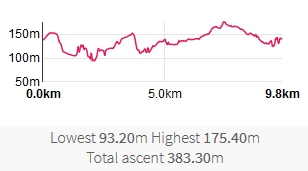
Distance and Time
10km / 6 miles, 4 hours.
Difficulty
Medium to high, due to ‘cunning plan’ failure (see below).
Our Rating (up to 5*)
4*
Description
This was based on the walk ‘Rowley Burn and Devil’s Water’ in the book referenced above, but we added an extra loop to extend the walk.
We started by parking in Juniper, not to the South of Rowley Burn as suggested in the walk book. We then walked a few hundred yards NE. Where a road goes off to the left we turned right down a track to the SE (526/035), following this for about 500 yards as it curved to the left to end up going NE. This took us to Pethfoot Bridge. The ‘official’ walk crosses the bridge here but we decided to try looping further north. We therefore continued North along 526/012. This route diverged from the river, ascending into woodland, then dropped again to cross Linnelswood Bridge. The PROW number now became 513/018, running North. This left us needing to go east, then south, in order to stay on the eastern side of the Burn and arrive at the eastern end of Pethfoot Bridge to rejoin the official route. Our cunning plan was to follow a path shown on the map that ran east through the wood then, where that ended, to find our own route through the wood for the last 200 yards or so to a track leading to the bridge. However, our plan turned out to be not as cunning as we hoped. The path was nowhere to be found, and the wood was a tiring maze of rocks, roots, slippery slopes and branches. Making painfully slow progress and fearing a twisted ankle we therefore exited the wood and walked along the boundary between the wood and fields until we could join the track down to the bridge. By the time we reached the bridge we were ready for a breather, a drink and a game of Poohsticks. We were now back on the official route, and on 543/029.
We followed this roughly SW, staying close to the Burn, for about half a mile. When we reached the road we turned right onto it, then almost immediately left onto a track continuing along the South side of the Burn (525/058). In a few hundred yards we arrived at the remains of Dukesfield Lead Smelt Mill, where it is worth spending some time looking at the remains and information boards. See http://www.geograph.org.uk/photo/3268724 for more information. We continued on for another mile or so to Redlead Mill. Here the base of a ruined wall provided a good seat for a rest and lunch.
After passing the house on our left we turned to our right towards Whitley Chapel (525/019), dropping to cross a footbridge, crossing a rise where all the trees had been recently felled, and dipping to cross another footbridge over Cobble Burn. Heading NW to pass between Mire House and Moss House, we reached Quakers Hole Wetlands (https://www.hexhamshire.org.uk/about-hexhamshire/the-wetlands). It deserves the name; in this section there are wooden walkways, but one of us did the rest of the walk with one wet foot. Following 525/012 and /013 brought us to Whitley Chapel. From here we briefly headed east along the road before crossing a stile to head north across fields to Whitley Mill (525/085), then east (525/009). Where the path clips the corner of a wood we turned NE into the wood and followed 525/084 to Rowley Burn then 526/023 to walk along it’s Southern bank. Arriving at Juniper we risked crossing at the ford (be warned: very slippery) and walked along the road back to the car.
