

Type of Walk
Moorland, tracks and minor roads.
Distance and Time
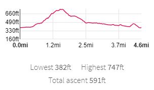
4.6 miles, 3 hours.
Starting Location
NY 783850
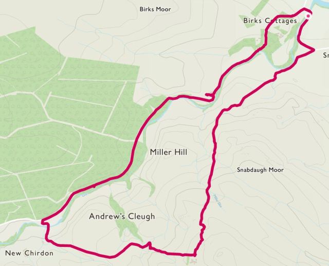
Map of Route and Elevation Profile
Difficulty
Fairly tough going up the moor, due to the long grass and reeds, easy once past Whitchester Farm.
Walking the Route
Just past the quaint Chirdonburn Bridge, we parked in a convenient off-road area and headed along the road towards Snabdaugh Farm. Here the road follows the Chirdon Burn, which gently meanders on the right. Turning right, along bridleway 552/005, we carefully tiptoed across the grassy field as the local farmer was spreading manure over it. Pooh! Heading in a SW direction we started our climb up Snabdaugh Moor. At times the path was unclear, but a swift reconnaissance of distant ‘posts’ reassured us that we were heading the right direction. An ancient trackway guided us at times:

Deep trackway with well defined ditches
Carrying on up the hill, stopping periodically to look at the marvellous views, we could see the remains of Dally Castle to our right, more on this later on. The air was fresh and silent, aside from numerous skylarks skirting around us overhead merrily singing. We gather these are a firm favourite of Mrs Reed (hello and happy birthday by the way). As we progressed further up the hill the views were stunning:
The terrain was rough going at times, long reeds, boggy areas and plenty of rabbit holes and sikes where you could easily break a leg if not careful. However, we plodded on stopping only briefly for a drink and a bit more view admiration.
Once at Whitchester Farm, with the hill climb now over, we mulled over what was the ‘correct route’ before setting off down the hill on bridleway 522/031. We briefly stopped for a quick bit of lunch (part 1 of 2) before carrying on down the track.

Looking back up towards Whitchester Farm
At the bottom of the hill, and just before crossing a very rickety bridge at Cagder Ford, we noted that our walk was part of the Reivers Cycle Route. Here we were met by two very friendly horses who seemed to be keen to meet our acquaintance.


Carrying on, we turned right onto the unnamed metalled minor road. Here we would follow the route of the Chirdon Burn all the way back to our starting point. A quick stop for lunch, part 2, saw us build up the energy to march on towards Dally Castle. On the way we were somewhat entertained by the local farmer ‘shrink wrapping’ his straw bails; fascinating! Sadly our limited WordPress account does not allow us to share the video.
At Dally Castle we stopped to look at the old ruins. Putting our mirrors away, we then looked at the old castle – or was it! An interesting sign board tells all….

Here are the remains of the ‘castle’ built on top of a natural mound:


Nearing the end of our walk, we followed the road past Birks until arriving back at Chirdonburn Bridge. Once up and over this we were back to the start, a little bit less energetic than when we started, but having had an enjoyable walk.
Our Ratings of the Walk (up to 5*)
- Scenery: 4*
- Historical interest: 3*
- Weather factor: 3*
- Overall enjoyment: 3½*
Reference(s)
Walks in Reiver Country, a Northumberland National Park publication.
Additional Information
- Walking the route: Neil and Paul
- Weather conditions on the day: Warm, cloudy but bright.
- Date of walk: 1st August 2020
