
Source
None.
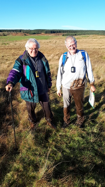
Today’s Walkers
Ed, Neil, Paul and Pete.
Start Grid Reference
NY743680
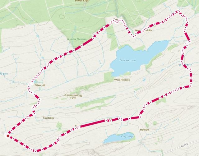
Map of Route
Type of Walk
Views, tracks, marshland, open scrubland and minor roads.
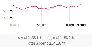
Distance and Time
12km / 8 miles, 5 hours 15 minutes (including stops).
Difficulty
Medium but hard in places, especially over the boggy section.
Our Rating (up to 5*)
3*
Description
Having decided to do a walk north of the Roman Wall, after some discussion we planned a walk round Greenlee Lough. The original plan was to stick closer to the south side of the Lough on the return, but fate intervened, as it does, reminding us that an impressive array of paper OS maps, digital maps, compasses, GPS’s and smartphones does not guarantee a trouble-free walk.
After parking in a layby near where the track led off to Gibbs Hill, we set off under a glorious blue sky. The metalled track gently descended with a mix of moorland and grass at the sides.

After crossing a couple of streams we then turned left onto PROW 523/033 to skirt round Gibbs Hill then joined 523/025 running NE.

After about half a mile we started passing Greenlee Plantation, though this was not immediately obvious as a large patch had been felled. Another half a mile saw us at Greenlee, where 523/025 turned SE towards the Lough and we followed it.


We then turned left onto 542/016, going NW again for a little over half a mile, passing West Stonefolds and East Stonefolds, nice stone farmhouses in a beautiful location. In patches the route was surprisingly muddy considering recent weather.


After East Stonefolds a track in a cutting provided us with a grassy bank to sit on for lunch. During lunch we heard a horn in the distance; just as we were trying to decide if it was a hunting horn, a large pack of hounds appeared over the hill we were looking at, barking in excitement, ran around for a bit then disappeared again.
After lunch we headed down South along 542/104, crossing Haughtongreen Burn. We were now on the Pennine Way. Ahead, we could see that the ground was boggy and we weren’t sure of the path, so we decided to head straight for the visible Pennine Way track running southwards and uphill. Unfortunately we ended up in a bog of grass and reed tussocks interspersed with mud and water. After one of the party fell over, getting one leg muddy, another decided to go one better by sliding both legs into a couple of feet of water. The other 2 of us made do with mud and water up to the ankles. On reaching dry ground we checked for damage which was limited to a wet mobile phone, unless you worry about loss of dignity (we don’t).
We had originally decided to follow a track along the south side of the lough; however as this isn’t a marked PROW, and we were keen to avoid more bogs, we decided to follow the Pennine Way route for a little way south instead. There was also the factor that we would have been out of the warmth from the low Winter sun.

In practice there were still boggy patches to be carefully negotiated, but after a bit of a climb we reached a well marked path along moorland (503/001) and turned WSW along it.

After a few hundred yards we passed a structure that we decided was either a lime kiln or the remains of an early Toblerone factory.


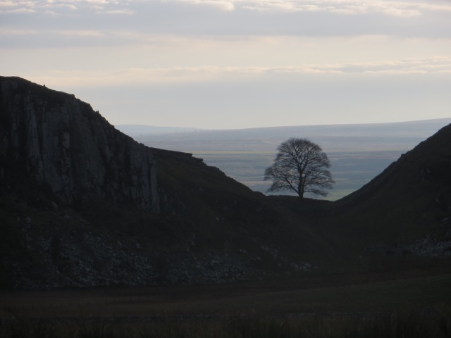
After a quick look at this we carried on. We still had 2½ miles to go, the sky was clouding over and both the sun and the temperature were dropping. We therefore hastened WSW along 503/002 then 503/024 then 523/015, though the low light allowed us to try taking silhouettes of Sycamore Gap, half a mile South of us.

Soon after that we joined a track (523/031) at Peatrigg, which led us back to the road a short distance from the car. After shedding the worst of the muddy clothes we then headed home, where a hot shower was doubtless top of everyone’s to-do list.
