
Source
“Prudhoe and Stocksfield Inter-Parish Walk” leaflet.
Today’s Walkers
Neil, Paul and Pete.
Start Grid Reference
NZ059615
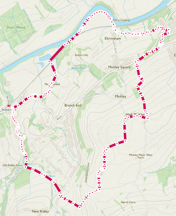
Map of Route
Type of Walk
Village, fields and riverside.
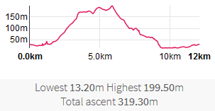
Distance and Time
12km / 8 miles, 5 hours 10 minutes (including stops).
Difficulty
Low to medium but hard in places, mainly on the second quarter of walk.
Our Rating (up to 5*)
1½*
Description
Starting at the carpark adjacent to Stocksfield Cricket Club, the sound of leather on willow ostensibly a distant memory, we set off on a misty but warm November’s day. Today’s walk was suggested by Pete, one of our band of perambulates who also happens to be Chair of the Prudhoe Pathforce, a group with a key interest in ensuring public access to PROWs is maintained.
Leaving the carpark we turned right and headed along the path next to the A695 a busy and, at times noisy, main road. Briefly skirting around a delivery lorry that had parked over the path, we crossed the road a made our way along footpath 509/045 which then merges with, and becomes, footpath 509/013. This took us behind the Guessburn estate but alongside the pretty Stocksfield Burn. Water gently tumbling over rocks made a pleasant background sound in this peaceful area. We continued past the rear of private dwellings, some still half-painted, others who had used the path as their garden refuse dumping ground. Midway along this path a brief moment of entry into the housing estate led us to the following artwork:


We exited the woods an onto the estate at the Tennis Pavilion currently undergoing extensive, and somewhat attractive, redevelopment. At this point we moved onto metalled roads with path 509/013 becoming 509/055, one of the shortest paths (ironically second shortest – see later) at less than 100ft in length. After completing the whole length of path 509/955 in record time, it became path 509/056 and is part of Ridley Mill Road. From this point on a notable number of substantial, and probably very expensive, secluded dwellings were seen, this being where the jet set of the area live. After surviving a senior moment, we turned left and headed up Batt House Road. This was the start of the second quarter of the walk and formed the steepest and hardest part of the road. Again we passed by many attractive houses before emerging at the top of road with the junction with New Ridley Road. Given the time of year, we were not surprised to have been spooked by various Día de Muertos effigies, such as:

Spooky skeleton
Diagonally crossing the road, stopping briefly for an oxygen break, we headed up footpath 509/028, initially running between the garden of two properties before moving onto open fields. Turning left onto bridleway 509/037 we continued up the hill, a very steep section being noted near the highest point. This route has somewhat of an identity crisis and becomes 538/004 and then 522/024. Changes in engineering technology were noted on this part of the route, with a combination of legacy and renewable power being evident:

Overhead power lines and wind turbine
At the junction with Modigars Lane we turned left along bridleway 538/003, a somewhat muddy route, passing to the left of Mickley Grange Farm, and onto bridleway 538/006. This was probably the bleakest part of our walk given the height above sea-level, the lack of views due to misty weather, the decreasing air temperature and a plethora of abandoned farm machinery and refuse littering the route:


The track twists and turns left and right before finally ending with a sharp turn left onto bridleway 538/059, referred to as Ward Lane, this running parallel to footpath 538/007 on the other side of the wall. This was another very muddy and rutted route. Passing to west of West Side Farm (sic) we ignored the instruction on the following abandoned gate:

Abandoned gate with ‘Shut the Gate’ label
Emerging onto the minor road at High Mickley, the former residence of one of our group, we turned right and headed up Bowler’s Hill although, no evidence of any cricket matches having ever taken place could be seen; perhaps a visit to a milliners was more the order of the day. We turned left down onto bridleway 538/011, recently diverted to avoid potential crop damage, none of which could be seen, i.e. no crops present. We followed the path, mainly due to the knowledge of our local rambler, the signage from here down to where it meets the A695 is very poor, frequently non-existent. Passing to right hand side of Collieryclose Wood we noted the, now former, golf driving range the lights of which no longer illuminate the evening sky.

Former golf driving range
We stopped for a lunch break at the edge of a field overlooking the Tyne Valley. I leave it to the reader to determine how scenic you think this spot was!

Lunchtime view
Lunch consumed and with flies now starting to become annoying, we followed the last part of bridleway 538/011 before emerging at the main road. Carefully crossing the road, which took some time, we walked alongside it before taking an agreed diversion. Here we turned right onto the B6395, West Road, before immediately turning down Eltringham Road, a steep and twisty road that runs through Horseclose Wood. Another small diversion took us right along Sycamore Grove, once again a former residence of one of our party, before turning left onto the final extent of Castle Road. At the end of Castle Road we took a dog-leg right and then left before using bridleway 538/060. This is absolutely the shortest path we have ever been on, around 46ft in length – and that’s being generous on the length as the actual path is more like 20ft! Crossing the A695 again we following restricted byway 538/051, the restriction being a large lump of concrete blocking the road. A scenic path, this is part of the Daft As A Brush Tyne Trail (see previous walk at Featherstone and Lambley Viaduct).

Trail sign showing ‘Daft As A Brush’ route marker
Autumn colours were very much in evidence now, as was a rather cute miniature horse, a full-sized one being close by for reference.


At the end of the byway, we turned right and headed down the final part of Station Bank, the station serving Mickley being a long way down the hill from the village and having been closed in 1915 (https://en.wikipedia.org/wiki/Newcastle_%26_Carlisle_Railway). After Eltringham Farm, and at the end of the road, we crossed the Newcastle to Carlisle railway via the safe crossing point. Passing by Riverside cottage we started our journey on restricted byway 538/092, evidence of just how restricted it is being repeated at various intervals with signage like the following:

No ‘nothing’
A brief stop next to the river (but not on your land dear anglers!) allowed us to have a drinks break but also to admire the view, discuss the old ferry landing (long since gone), the quaint houses at Ovingham on the opposite river bank and also to watch a bird drying it’s wings whilst perched on a rock.

View looking east downstream towards Prudhoe
Carrying on we walked along the peaceful, sheltered and scenic riverside occasionally chatting to several responsible dog owners. We followed claimed right of way 538/089 since the previous path formerly diverts out into the middle of the River Tyne! A small area of riverside erosion was noted but afforded us the opportunity for one final autumnal scenic view, albeit still overshadowed by the misty murky day:

Final view looking west towards Stocksfield
At the end of 538/089 we crossed a small brook and turned left onto claimed right of way 509/058. This led us underneath the railway line via a stone arched bridge where we followed the farmer’s track, this joining with footpath 509/012. Stopping for a quick hello with the farmer and his [rescue] dog, we carried on alongside the northern edge of Merry Shield before turning left and heading up towards the minor road. Here we noted recent storm damage with three, very large, trees having being snapped off part way down each of their trunks. Turing right onto the minor road we continued along path 509/012 before emerging at the junction with the A695. Turning right we followed the footpath very briefly before arriving back at the carpark, this now being full with parents1 collecting their children1 from the local school.
Note 1: Parents also covers guardians, carers and any other authorized person collecting children from the local educational establishment. Children is a definition in this case referring to male, female or non-binary individuals who are legally required to be educated and are not yet defined as adults. Yes, we are PC and it was a long day!

Pingback: 19th January 2019. Wylam and Newburn. | Middle Aged Ramblings