
Source
None.
Today’s Walkers
Ed and Neil.
Start Grid Reference and Walk Direction
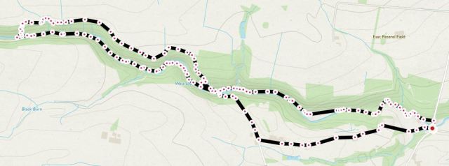
NY930610, clockwise around a loose figure-of-eight. Notes: a) The start and end points are opposite the Dipton Mill public house; b) We chose to walk round the edge of the figure-of-eight but other walkers can choose to cross at the mid-point, if desired, but see the text below about how steep and dangerous the walk was.
Map of Route
Type of Walk
Lanes, woodland and riverside.
Distance and Time
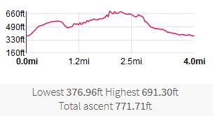
4 miles; total time of 4 hours, including generous breaks for mid-morning coffee and lunch. Note that significant time was ‘lost’ due to having to scramble under and over fallen trees, as well as the documented ‘vertical climb’.
Difficulty
Extremely hard due to unclear paths, significant fallen trees, a blocked route at the westerly end, multiple river crossings (without bridges) and an almost vertical ascent when the path was finally blocked.
Our Rating (up to 5*)
4*, even taking into consideration the difficulty of the walk.
Description
We started off by parking opposite the Dipton Mill pub in Hexhamshire on a lovely warm, sunny day. Our route took us westerly, commencing with a walk up the single-track road (unnamed) leading to Shield Green. Initially there was a reasonably steep climb, but with a good road surface progress was easy and pleasant with some views over the countryside.
At the point where the road takes a 90° turn left, at the crossroads with a track and a byway, we turned right onto byway 526/013. There’s even a sign here saying ‘no vehicles’, but given the terrain we were not surprised. We continued down the byway, steep and slippy in places, until we reached the only footbridge we saw across the West Dipton Burn.
After crossing the river we took footpath 524/055 alongside the river bank. We were afforded many charming forest and river views on our trek. Here is a selection of what we saw on the day as a slideshow.
At one point, after crossing the river many times, we reached a point where there was no visible footpath on either side of it. Taking an executive decision, as well as the fate of our lives into hand, we scrambled up an extremely steep (we estimated 4 in 1 – not 1 in 4!!) hillside. Upon reaching the top, as well as being thankful that we were still alive, we turned right along footpath 524/015, this being the path we always had intended to use on our return leg.
After stopping for lunch, a mixture of healthy salad and meat stuffing sandwiches, we followed the easterly path through the trees. In places even this path was blocked but, unlike on the way up, alternative routes were available to us.
It’s interesting what you find in the forest during your walk – can anyone explain this one?
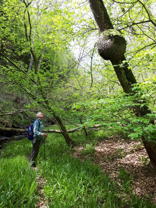
Well it’s not a bees or wasps nest and it is fairly solid with a bark-like texture, but what is it?
Upon exiting the woods, we turned right and crossed the road bridge next to the Dipton Mill pub and arrived back at the car park. Today was one of those days where you absolutely needed walking poles. For one of us, it was fortunate that the walk tested his brand new poles out. Without these we would have been in some difficulties at times.
Overall, we thoroughly enjoyed this walk despite the significant challenges presented to us on the day. Thankfully, no one fell into the river ‘up to their middle’, or even at all!
Finally, have you ever seen someone do an impression of a flamingo in a river…..?

The now world famous “Man doing a flamingo” picture.

Pingback: 15th June 2019. Broomley. | Middle Aged Ramblings